What exactly happened to Malaysian Airlines Flight MH370 and the 239 people on board after it took off from Kuala Lumpur on 8 March 2014, bound for Beijing?
The team at Fugro’s office in Perth, Western Australia, believe that they are closing in on the answer.
The geotechnical services company has two vessels searching the seabed for the Boeing B777-200, under a contract it won from the Australian Transport & Safety Bureau (ATSB). Its team has just a few thousand square kilometres left of the 120,000 sq km it has been scanning — a job it expects to complete in June.
“We feel that every day could be the day,” says Fugro Survey’s Perth-based managing director, Steve Duffield. “We don’t want to give up.”
There are plenty of people claiming that the ATSB has been looking in the wrong area. Conspiracy theories abound as to why the plane vanished and where it might be lying, with private individuals talking of launching their own searches to prove their pet ideas.
But Fugro made its own early play on how to solve the mystery.
After the baffling disappearance, Fugro Survey’s deputy managing director, Paul Kennedy, who is also one of the company’s business development managers, began writing a thought paper on how to search for the plane.
He and his team tracked down the report on the search for AF477, the Air France airliner lost over the Atlantic Ocean in 2009 while flying from Rio de Janeiro to Paris with 228 people on board. It was finally recovered in 2011.
After the disappearance of the Malaysian aircraft, the Australian Maritime Safety Authority (AMSA) began a search-and-rescue mission, listening for the “pings” from the missing plane’s underwater acoustic beacon.
But after 30 days the AMSA deemed all on board to be lost and the portfolio shifted to the country’s accident investigation body, the ATSB.
By then a copy of Kennedy’s paper had reached the ATSB and Fugro was invited to a mini-tender. It won the contract to start mapping the seabed and building a digital terrain model to serve as an aid for the eventual search for the missing aircraft — a mirror of the approach used to look for AF477.
This sort of job is Fugro’s bread and butter. It works primarily for oil & gas companies conducting hydrographic surveys, looking for geological problems and conducting debris searches when offshore work has been completed.
The MH370 search area, however, was something new for the company. Located closer to Australia than South Africa, although not by much, it is a five- to six-day trip of about 1,300 nautical miles to the site from the West Australian port of Fremantle.
Fugro has had two boats out there continuously on 42-day missions. Once in position their teams get 30-32 days of on-site search time.
“Nobody had done work out there,” Duffield says. Previous seabed features, including the 1,200km oceanic plateau Broken Ridge, had mainly been mapped from satellite data showing the effect of gravity on the water. Google Earth maps reveal intensive small survey areas where research budgets have allowed more detailed mapping, Fugro lead geophysicist Magnus McNeil-Windle explains.
But it was not the remoteness of the search site or the water depths of 3,000-4,000 metres that were the most challenging elements. “The biggest difference between what we normally do and this is scale,” Duffield says.
Working for an oil & gas company, Fugro might do surveys ranging from five to 20 sq km. The ATSB initially contracted it to cover 60,000 sq km — the largest survey of its type ever conducted.
The resulting detail is proving fascinating to the scientific community. Fugro is constantly fielding calls from scientists who are keen to start interpreting the information.
Using what is essentially an echo sounder, the bathymetric data has revealed underwater volcanoes, mountains and mud mounds not know before. More relevantly to the search, the spot data for particular points revealed a 1,000-metre difference in places to figures on file from the existing satellite data.
“We didn’t know what to expect,” Duffield says. “We knew there must have been some features down there. It just demonstrated that this process set out by the ATSB, which was somewhat copied from AF477, was definitely the right procedure.”
In the event, the ATSB job turned into 100,000 sq km as the search area moved further south. This was in response to seven arcs from data produced as a communications satellite connected with the plane hourly during what appears to have been its unplanned flight over Penang Island and the Indonesian island of Sumatra before it turned south. The sixth arc was out of sequence and the seventh never completed, which is where the plane is assumed to have hit the water.
Satellite wobbles and an eclipse also had to be factored in when determining where to focus the search.
Fugro was on site by June 2014 and completed the mapping job in December that year. Then things got a little more competitive.
In June 2015 the ATSB put out a worldwide tender to search for the aircraft. Of around 30 interested parties, 14 eventually tendered and five were shortlisted. Fugro put together a panel of experts and won the job.
It was a high point for the company, which had expected to be asked to form a consortium with other bidders. There were objections from rival bidders, but the ATSB said Fugro had the most appropriate technology and price.
Fugro has not said publicly what the deal is worth, but it is not its biggest contract. The company gets paid for data gathered, so it must factor transits and weather downtime into its costs.
Duffield explains that the initial brief was to search 60,000 sq km — of which Fugro was originally going to undertake half in partnership with Malaysia — looking for objects measuring two metres by two metres and more.
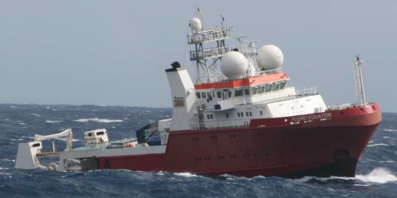
The two main workhorses for the job are the purpose-built 65-metre survey boat Fugro Equator (built 2012) and the 70-metre Fugro Discovery (built 1997), a former Norwegian coastguard vessel. Each carries around 30 personnel — crew and specialist scientists.
Both vessels have been using a deep towfish, which is towed at 150-200 metres off the seabed on a 10km, armoured fibre-optic cable, using side scan sonar to search for objects. The company uses the digital model from the bathymetric survey so it can fly the towfish up and down the seabed floor features.
The search is conducted along 700km lines executing an eight-hour Williamson turn at the end of each to line up for the next, with shorter lines to cover the infill data.
The Fugro Supporter has also been used to conduct surveys with a programmable autonomous underwater vehicle (AUV) filling in some of the data gaps caused by the terrain. This year Fugro’s chartered vessel Avila Harmony has also been on AUV duty.
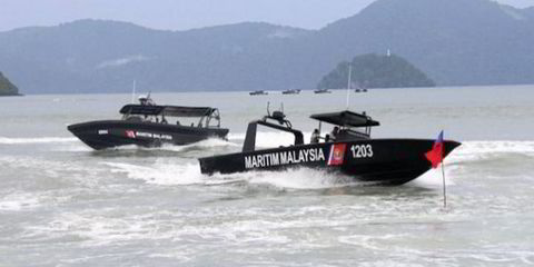
The Malaysian authorities initially supplied a vessel, the supply boat Go Phoenix, which has since left the site. Because 152 of those on board MH370 were Chinese, China recently brought in the salvage tug Dong Hai Jiu 101 to join the search.
“We are working a little bit slower than three knots, which equates to about 6km per hour,” Duffield says. “It is like searching the area of New Zealand at walking pace.”
The side scan sonar can give a visual of an object, and the shadow it throws up can be measured to give its height and depth. Seeing behind the shadow and lifting the towfish over the mountains creates additional work with data gathering.
On the boat, the team see a waterfall of data flowing all the time. This is given an initial review and objects of interest are highlighted. It is then packaged from 8Gb daily to 2Gb and sent to Fugro’s Perth headquarters and the ATSB in Canberra, on the other side of the country, where the analysis work is undertaken, along with a further check by an expert in the US.
“Our concern is the false negative,” Duffield notes. “What we don’t want to say is: ‘This area does not contain an aeroplane’ and be wrong.”
Fugro has a clear picture of what might indicate that it has found MH370.
“We are looking for a debris field,” Duffield says. “Based on other aircraft maritime incidents, it is likely to be somewhere between 150 and 250 metres wide and about 500-800 metres in length.”
The aircraft debris is expected to have height and be proud of the seabed due to the soft sediment that tends to resist the impact of a flat object.
There have been finds to date: two shipwrecks. Fugro Supporter took photos of the first, the wreck of a coal-burning wooden ship whose anchor dates the vessel to 1815-35.
It was the first real debris field the team had seen. Tony Abbott — the then Australian prime minister — was in Europe and had been briefed to be on standby to make an announcement that the plane had been found. “That’s how positive it all got,” Duffield adds.
He, Kennedy and the ATSB’s general manager of surface safety investigations and project director for the search, Peter Foley, were scheduled to do media events on 7 March 2015, the day before the first anniversary of the plane’s disappearance and the night the team were due to put an AUV down to take a closer look at the shipwreck. They could say nothing. Duffield was interviewed on television, but the cricket fan says: “I was playing it with a straight bat.”
The global press attention has not always been great. Duffield has been bruised by his experience with a British tabloid newspaper last year when he claims he was falsely quoted as saying he knew where the plane was.
In the ensuing fallout he and the team went for media training. Now, he says, “We don’t talk about why or where we are searching, but we do talk about life on board the boat, equipment and the ships. We didn’t know we had to have a script, but now we stick to that script.”
Fugro personnel and the wider team are mindful of the purpose of their work. Foley starts meetings by asking everyone to remember the objective is to find this aircraft and so bring closure to the next of kin. Duffield says the single focus helps.
He describes the visit of the Perth-based wife of one of the passengers to Fugro Equator to see what was being done. During the visit the woman spoke about the loss of her husband. “That was certainly very moving for everyone.”
When — Duffield focuses on “when” and not “if” — Fugro finds the plane’s debris field on the side scan, the company is required to send an AUV down to map and photograph it, so that engineers can quickly identify where key items such as the black box flight recorder might be lying.
Fugro’s vessels will then “go black”, in an agreed communications lockdown, to allow the next of kin to be informed minutes ahead of any public announcement.
The ATSB has already shortlisted several companies, including Fugro, for a recovery operation of the plane and any human remains. The bureau is looking for ships with 60-bed accommodation, dynamic positioning and large deck space areas.
But Fugro’s current mission formally finishes once the 120,000 sq km search phase has been completed in June.
Pieces of wreckage that are believed to be from the aircraft that have washed up on the far side of the Indian Ocean, on the island of Reunion and the coast of South Africa, Mozambique and Mauritius, have positively changed the outlook. “It does feel real,” Duffield says. “There are still lots of ifs, buts, maybes, would-bes, but it suggests that the plane did crash in the southern Indian Ocean.”
And the big — almost unspoken — question: if the plane is not found, then what?
As TW+ went to press, the ATSB stated for the first time it was possible it might never be found.
Duffield says that if the aircraft is not found within the defined search area, there is a need to go back and look at some more assumptions.
Heavy weather: Hull or high water
Life for Fugro’s search team has had its moments.
Steve Duffield, like his fellow West Australians, thought he knew all there was to know about cyclones, even though they rarely make it as far south as Perth.
But the team soon found out that there are other storms that form to the north of Madagascar — perhaps better known to surfers — when three of the company’s boats were hit by cyclones Bansai, Diamondra and Eunice in February 2015.
Fugro Equator recorded a 16.8-metre wave height,while another wall of water set off Fugro Supporter’s Emergency Position Indicating Radio Beacon, leaving the boat locked down for four days before it was safe to send someone out to turn the beacon off.
Newly employed surveyor Hayes Ballantyne, who was on his first offshore trip on Fugro Equator during the rough weather, thought it was the norm until he returned to shore and checked the Beaufort scale.
The team see few commercial ships in the search area, aside from large tuna fishing fleets. However, sightings of albatross, pilot whales and dolphins are plentiful.
Each boat has a project manager — referred to as the party chief — who liaises with Fugro search director Peter Kennedy every day.
Duffield says that Kennedy lives and breathes the search daily, reading the logs and responding to calls and incidents late into the night.
The boats do interact with each other, with friendly competitions to see which can cover more kilometres or swings in a day — and on one pressing occasion exchanging fresh coffee for supplies of crisps. “There is a spirit of co-operation,” Duffield says.
There have been problems.
The team have lost two deep towfish. On one occasion they came straight back to port, attached the spare and were back on site 12 days later. The other time they used Avila Harmony’s remotely operated underwater vehicle to recover the towfish in four hours.
Duffield has not missed a single port call for any of Fugro’s vessels since the job started. He says morale among those on board always seems high. “They understand the importance of what they are doing. They are very methodical and very professional about the search. That is the best they can do, and that will deliver the right result.”
PLUS POINT
The in-house-designed Fugro Equator carries its data-processing equipment deep in the base of the vessel, where there is the least movement. Hydraulic and electricity systems are separated from the hull to help keep the vessel quiet in the water, and the sonar room sits directly above the keel.
The company has suspended a gondola from the keel to hold the sensors, in effect isolating them from the hull. The aim is to separate the sensors from aeration created around the vessel as it moves through the water, to obtain the most accurate readings of sound waves in the water. “Aeration is our enemy,” Steve Duffield says.